Bill Xu reports on his experience attending “Remote Sensing for Disaster Response” at the MIT BeaverWorks Summer Institute. The virtual class of 28 students hit the ground running as they collaborated on their first project—building something in Minecraft with assistance from TA instructors.
“The first week was all about learning the coding foundation for the projects we will do in the future weeks. On Monday, after the introductory speeches and icebreaker activities, we reviewed the basics of Python: data structures, looping, and conditional statements. On Tuesday and Thursday, we talked about data manipulation through Pandas and NumPy. Using these skills, we analyzed Pokemon statistics and found out that heavier Pokemon are faster than lighter Pokemon. We learned about graphing data and shapes on the final day of the week,” Bill explains.
“On Wednesday, we went on a virtual field trip to the Humanitarian Assistance and Disaster Relief Group at the MIT Lincoln Lab. Throughout the day, several researchers entered the zoom meeting and spoke about their research, including landslide detection through LiDAR, interfaces to track hurricanes and assist in evacuation decisions, and a secure communication system for humanitarian aid and military groups. My favorite was the presentation about landslide detection through LiDAR, which used lasers to map the terrain and generate data that can be used to predict whether a landslide will occur. Currently, their prediction models are 94% accurate at predicting landslides. The presentations were all very interesting and I learned a lot about disaster response,” Bill adds.
In addition to classwork, students listened to distinguished speaker presentations on cutting-edge computer and engineering topics.
“My favorite talk from this week was about how the creation of fiber-optics accelerated wireless communication and the representation of digital information. The talk detailed the new opportunities that came from the development of fiber-optics that resulted in the World Wide Web, and the opportunities that it will create in the future. The content was very fascinating, and I took away a lot of useful knowledge,” Bill says.
Week Two
For the second week, Bill learned about image processing, satellite imagery, networks and routing, and GIS analysis.
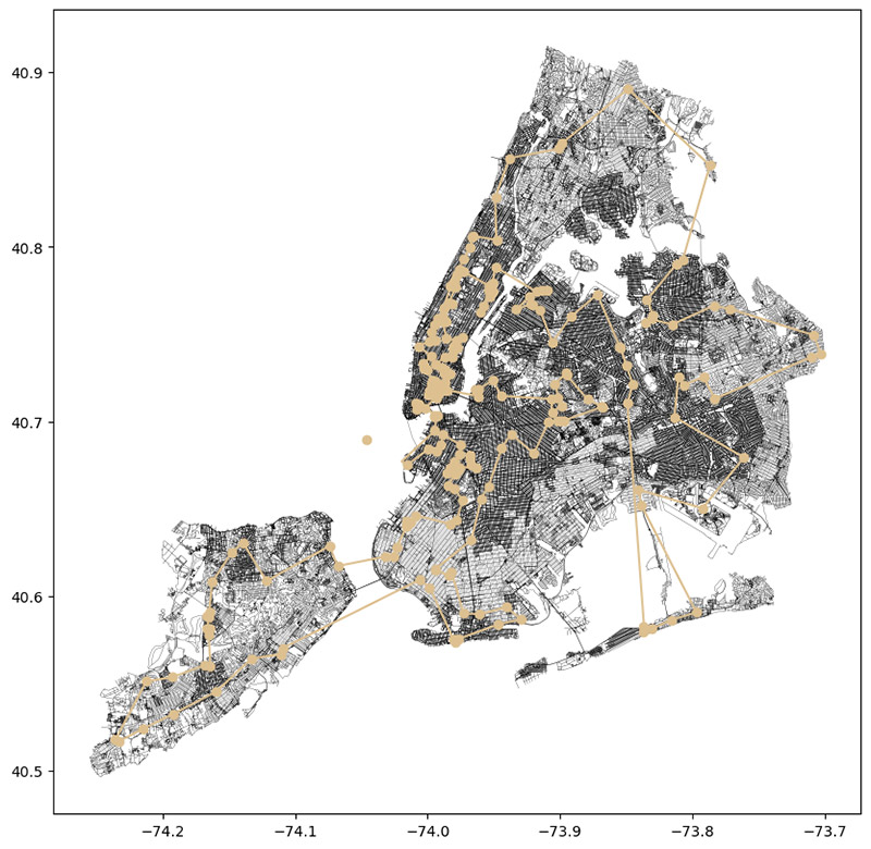
“During our lectures, we utilized publicly available datasets and explored their uses. Using the OpenStreetMap dataset, we found the shortest path to visit all the ice cream shops in New York City and that there are 34 fast food restaurants within walking distance of MIT. Using elevation data from satellites, we found that there is a relation between the size of an airport and its altitude. Through the use of more elevation data, we found the areas in Massachusetts that are the most prone to flooding,” Bill reports.
Bill says that he and his group continue to work well together on shared assignments.
“From the outset, we engaged in brainstorming sessions to devise efficient strategies for tackling the coding exercises and optimizing our data analysis techniques. Not only did we quickly finish the coding exercises, we also did well on the mini-project assignments, where we are to analyze data to answer an interesting research question. During the week, we investigated the relations between the tree cover in an area and the type of land usage (industrial usage had the least tree coverage) and between the median income of an area and its distance from a university,” Bill adds.
“My favorite lunchtime talk from this week was about how communities most burdened by climate change are also those with the least resources to cope. The speaker went into MIT Lincoln Lab’s five flagship Climate Grand Challenges projects, which are focused on solving five climate change challenges. Lincoln Lab has already created climate resistant cities in Bangladesh and developed farming techniques for more climate resistant crops, and is currently in the process of creating a cheaper way of building wind and flood resistant houses, along with other projects,” Bill says.
Week Three
During his third week, Bill Xu and classmates learned about aerial imagery, structure from motion, 3D data, and machine learning. The class also worked on and presented several projects.
“Using aerial imagery and the Google Earth Engine, we investigated the damage caused by Hurricane Maria, which devastated Puerto Rico in 2017. We generated maps that showed which areas had been flooded during the hurricane and calculated the total flooded area and the number of people affected. We learned about using Pillow and OpenCV to process images. Using our newfound knowledge, we looked at pictures of rubble and automatically drew lines around all the pieces of debris. We used structure from motion methods to generate 3D models of various objects by taking many pictures at different angles,” Bill Xu explains.
“This week, my group consisted of several students who were exceptionally talented at coding. We made very few errors throughout our projects, and quickly realized and corrected our mistakes. Throughout the week, we worked on and presented several projects. The first project was a hurricane damage analysis similar to what we did in class. We studied Hurricane Irma, which tore through Florida in 2017 and made a slideshow presenting the results we found. For our second project, we looked at pictures of the wildfires in Greece. By extracting the color channels, we could very easily automatically determine which sections had already been burned,” Bill adds.
“My favorite lunchtime seminar from this week was about the complexity of the soil. The speaker explained that the soil contains more valuable nutrients than the rest of the non-ocean biosphere combined. Managing these nutrients is a complicated society of microbes that biologists are scratching the surface of. These microbes could have potentially useful properties that would massively benefit humanity. The speaker has been studying microbes that could facilitate redox reactions, where electrons are transferred between two particles. The ability to facilitate these reactions could be used to treat diseases or fixate nitrogen to create fertilizers, in addition to many other things. Understanding just a small portion of the microbes in the soil would completely revolutionize an industry,” Bill reports.
Great work, Bill. We wish you much success with your work on this challenging topic!
>> Read Bill Xu’s final report (PDF file, 74 KB).
>> Learn about other students’ experiences in the GFF Scholarship Program.